
This 1924 memorial marks the location of Thomas Cresap's 1730 home "Pleasant Garden" on the Conojohela flats along the Susquehanna river near present day East Prospect, Pennsylvania.

Captain
Thomas Cresap
1703 - 1790
A Marylander
Settled on these indian lands of
Conejohela in 1730
and held them for Lord Baltimore
against the Penn Proprietors
until 1736, when in the border war
he was burned out
of this log house or fort
near this marker toward the river
on his plantation "Pleasant Garden"
and carried prisoner
to Philadelphia
Marked by
the Pennsylvania Historical Commission and the Historical Society of York County
1924
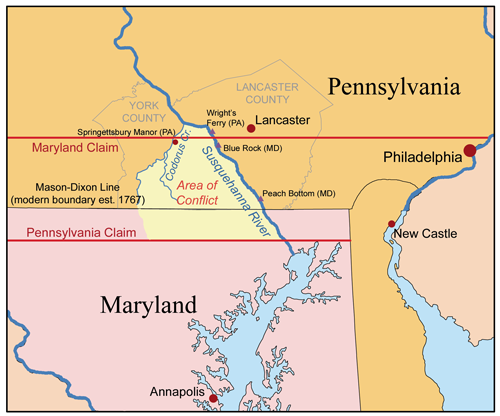
In the 1730's, heated legal arguments between the sons of William Penn and Charles Calvert, 5th Lord Baltimore, over the location of the northern boundary of Maryland were in full swing. The Maryland Charter called for a boundary at the 40th degree of latitude. The Penns claimed a line far enough south to provide access to the top of the Chesapeake Bay. This map from Wikipedia illustrates the situation:
As Wroth puts it:
Pleasant Garden was just south of Wright's Ferry, at the spot marked Blue Rock on the map above at about the same latitude as Philadelphia, 15 or so miles north of the Mason-Dixon Line.Into the scene of discord caused by this contest entered Mr. Thomas Cresap when he bought the tract called Pleasant Garden and acknowledged the Proprietary of Maryland as his overlord. Cresap himself was not precisely an angel of peace; his hand was fashioned for the cudgel rather than for the olive branch, and what has since been called the "Conojacular War" revolved principally about this aggressive Yorkshireman, who desired nothing so much as to secure and hold a bit of land for himself and his children.
A series of violent incidents between Cresap and the Pennsylvania authorities became known as the Conojacular (or Conojocular) War. Cresap earned the name "The Maryland Monster" during this period. The border war ended in 1736 when the Pennites burned Cresap out of his home and captured him. He was taken to Philadelphia which he declared to be "The Prettiest town in Maryland." In 1738, a temporary line was agreed upon 19 miles south of the 40th parallel.
While Charles Mason was surveying the line that marked the final 1763 settlement of the boundary dispute, he met Samuel Smith who had been Sheriff of Lancaster county when Cresap was captured. Here's the entry in Mason's diary for January 17, 1765:
Returning at Pechway, I fell in company with Mr. Samuel Smith who in the year 1736 was Sheriff of Lancaster County, now three counties, Lancaster, York and Cumberland, who informed me that the People near the supposed Boundary Line were then at open war. About ten miles from Lancaster on the River Susquehanna one Mr. Crisep defended his house as being in Maryland, with 14 Men, which he surrounded with about 55. They would not surrender (but kept firing out) till the House was set on fire, and one man in the House lost his life coming out.The Conojohela flats where Cresap established Pleasant Garden was a large shallow section of the Susquehanna known for the quantities of ducks that fed there. Today, the place where Cresap's house stood and the whole Conojohela flats are drowned under the backwater behind a power dam.

The 1924 stone and a 1960 Pennsylvania highway marker are along Long Level Road in a spruce grove in a boating resort community.


Some time in the mid-18th century, this solid bluestone house was built nearby. Known as the Tritt or Dritt house, it is now the Zimmerman Center for Heritage.


I grew up and live in the area of Cresap's Fort (Wrightsville and East Prospect). It's neat to realize how many history changing events took place in this area! I didn't see it in this page but, I believe, The present day area name of Canadochly Valley is derived from the name Conejohela. Thank you for your work!
ReplyDeleteRich Fritz rjfpc@comcast.net